Barren Measures Fm
Type Locality and Naming
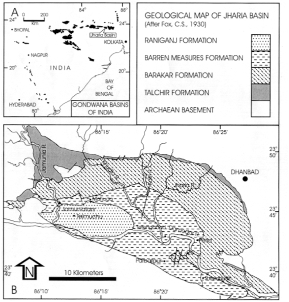
Barren Measures was named by Fox (1930 a, b) for the non-coaliferous lithounit sandwiched between two major coal-bearing formations, the Barakar Fm and Raniganj Fm. However, as the formation lacks geographic component, the name Kulti Formation was suggested by Sastry et al. (1977) for the Barren Measures, but the later name is still in vogue. The name Kulti was earlier also proposed by Fox (1931 a, b) from Raniganj coalfield but was given the designation of stage. Kulti Formation is named after the village Kulti (23o44':86o51'). Type area is in Jharia Coalfield (Dasgupta, 2005; fig.1), type section has not been designated. [Original Publication: Fox C. S. 1930. The Jharia Coalfield. Mem. Geol. Sur. India, 56, 255.]
[Figure 1: A ) Map of Peninsular Indian Gondwana basins. B. Geological map of Jharia Basin (Adapted from Dasgupta 2005)]
Synonyms: Kulti Fm, Barren Measures, Ironstone Shale
Lithology and Thickness
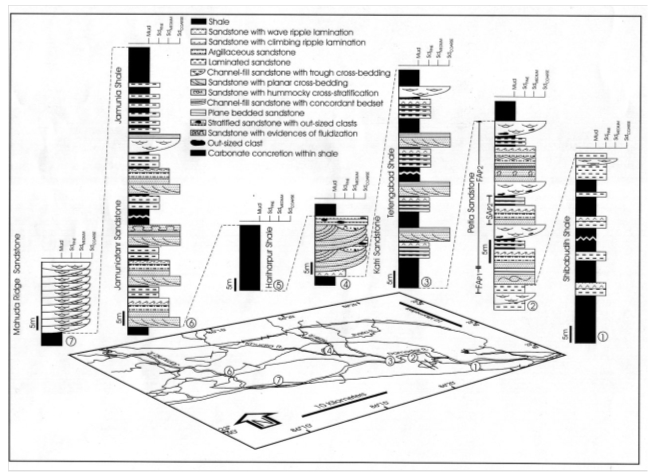
Clayey sandstone. Measuring approximately 750 m (Dasgupta, 2005), it mostly comprises of alternation of cross-bedded medium to coarse grained, greenish to grey white, feldspathic, micaceous and ferruginous sandstone with shales. Dasgupta (2005) divided the Barren Measures into Shibabudih Shale, Petia Sandstone, Tetengabad Shale, Katri Sandstone, Hariharpur Shale, Jamuniatanr Sandstone and Jamunia Shale members. The carbonaceous shale with ferruginous bands is the typical lithology of the formation. Shales are subordinate to sandstone. Pebbles of quartz are seen at places in Pranhita-Godavari Valley. The formation is devoid of workable coal seams; hence the name "Barren".
[Figure 2: Lithocolumns of the Barren Measures measured at different locations (see schematic map) showing the general character of different members (Adapted from Dasgupta, 2005)]
Relationships and Distribution
Lower contact
The formation has conformable and gradational contact with the underlying Barakar Formation. The bore-hole data from the Raniganj Coalfield indicate the lower boundary of Kulti (Barren Measures) Formation has overlap with the Barakar Fm. The contact of Kulti Fm and Barakar Fm is arbitrarily placed above the uppermost coal seam of the Barakar Formation (Sastry et al., 1977; Peter, 2009). In Pranhita Godavari valley an angular discordance has been noticed between underlying Barakar Fm (dip 15o-18o) and Barren Measures (dip 6o-8o) (Raja Rao, 1982).
Upper contact
The formation has conformable and gradational contact with the overlying Kamthi Fm / Raniganj Fm. The contact between Kulti (Barren Measures Fm) and Raniganj Formation is arbitrarily placed below the lowermost coal seam of the Raniganj Fm (Fox, 1930).
Regional extent
It is recorded from almost all the Gondwana basins. It is well recognized in the Damodar Valley coalfields as well as in Auranga and Hutur coalfields to the west.
GeoJSON
Fossils
Trace fossils are Skolithos, Arenicolites, Copophioides, Diplocraterion, Phycodes, Rhizocorallium, Lingulichnus, Rosselia, Palykladichnus, Catenichnus, Planolites, Macaronichnus, Thalassinoides and Psilonichnus (Mukhopadhyaya, 1996); Megaplants: Cyclodendron leslii, Neomariopteris hughesi, Glossopteris (Kar, 1968 a; Shah et al. 1971), Miospore: Densipollenites, Faunipollenites, Striatopdocarpites (Bharadwaj 1974, Kar, 1976, Jha, 2006). Vertebrate fauna has been reported from the Motur Formation of Pranhita-Godavari Valley, which is homotaxial to the Barren Measures, comprising dicynodont: Endothiodon sp., Cistecephalus and a captorhinomorph reptile (Kutty, 1972).
Age
Depositional setting
The Barren Measures Formation characterized by alternate disposition of shale and sandstone dominated units in the Jharia Basin developed through fluvial–lacustrine interaction in a tectonically active half-graben basin (Dasgupta, 2005). Hota and Das (2010) studied the Barren Measures Formation of the Talchir Basin and recognized fining upward cycles comprising of conglomerate or coarse-grained sandstone at the base sequentially succeeded by medium-and fine-grained sandstones, shales and coal at the top. According to these authors, the cyclic sedimentation of the Barren Measures Formation was controlled by autocyclic process which occurred due to the lateral migration of streams triggered by intrabasinal differential subsidence.
Bhattacharya and Banerjee (2015) contrary to the continental fluvio-lacustrine depositional setting suggested for the Barren Measures attributes marginal marine tide–wave interference for the Barren Measures based upon the study of the formation exposed along the Bokaro River section, West Bokaro Coalfield, Jharkhand. They opined sedimentation to occur in shallow subtidal to intertidal flat facies, affected by intermittent strong to weak reworking by open marine waves/storms and tidal currents in a sheltered, tide-dominated estuary, with transgressive phase onlaping the estuary system.
Additional Information
Some calcareous mudstone contains phosphatic nodules (20-30% P2O5) (Mukhopadhaya, 1996). Phosphatic marly claystone is well developed within the Barren Measure of the Ib River and Mand-Raigarh coalfield (Acharyya, 2005). Thin impersistent phosphatic marly and sideritic beds with 12% P2O5 content have also been recorded from West Bokaro and South Karanpura coalfields of Damodar Valley (Acharyya, 2005).
References
Acharyya, 2005; Bharadwaj 1974; Dasgupta, 2005; Fox (1930 a, b); Fox (1931 a, b); Hota and Das (2010; James Peter, 2009; Jha 2006; Kar, 1968 a; 1976 ; Kutty, 1972; Mukhopadhaya, 1996. ; Raja Rao, 1982; Sastry et al. (1977); Shah et al. 1971;
Bhattacharya, B. and Banerjee, P.P. 2015. Record of Permian Tethyan transgression in eastern India: A reappraisal of the Barren Measures Formation, West Bokaro Coalfield. Marine and Petroleum Geology, 67, 170-179.;

